Step by Step process for Implementation of GIS
1. Introduction to GIS
Geographic Information Systems (GIS) are fundamental tools for learning geography. It is a system (hardware + database engine) that is designed to efficiently, assemble, store, update, analyze, manipulate, and display geographically referenced information (data identified by their locations). GIS therefore encourages peoples to think spatially, or geographically. GIS is much more than a container of maps in digital form. GIS is a spatial decision support system.
2. Process for implementation of GIS
The most effective way to make GIS successful during plot management is to use it throughout the preparedness efforts. GIS development practices pursues the below workflow.

(Workflow of GIS)
Broadly GIS activities are performed in two different categories, such as GIS Development and GIS Integration. Let us step by step understand the background of each of these GIS activities.
1.1. GIS development
Below are the GIS practices and procedures by following which application owner will be able to manage GIS based application efficiently.
1.1.1. GIS Data Assembly
Data can be collected from the various sources and techniques to be ported in to GIS environment. The common ways are, digital imaging which substitutes the classic image of photogrammetry for a better depiction of the area hence better data collection. Laser scanners and SAR (Specific Absorption Rate) which allow the easier illustration of areas like forests when it is difficult to illustrate them in other ways. Cameras equipped with geographic information system technologies for immediate, automated and directly digitized results, mainly about resource potentials. Stereo images from high resolution and close-range photogrammetry with ortho photos, digital surface model etc. Of course, the main sources are GPS, remote sensing and photogrammetry but all the mentioned methods and applications are useful too.
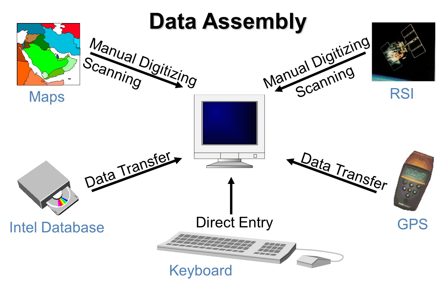
(Data Assembly)
1.1.2. Data Preparation
Preparing data means ensuring datasets can be validly analyzed together and reducing processing time as much as possible. Data preparation tasks often include projecting data, reducing the spatial extent to the area of interest, deleting unneeded attributes, creating new attributes, cleaning up attribute values etc. This can be achieve through ArcGIS geo processing tool.
(Data Preparation)
1.1.3. Data Storage
There are various way provided by ESRI for storing spatial data. They encourage you to put your data in geodatabases, which are organizational structures for storing datasets and defining relationships between those datasets. Different flavors of geodatabase are offered for storing different magnitudes of data.
- Personal geodatabases are a small, nearly deprecated form of geodatabase that store data on the local file system. The data is held in a Microsoft Access database, which limits how much data can be stored in the geodatabase.
- File geodatabases are a newer way of storing data on the local file system. The data is stored in a proprietary format developed by Esri. A file geodatabase can hold more data than a personal geodatabase: up to terabytes.
- ArcSDE geodatabases or “enterprise geodatabases” store data on a central server in a relational database management system (RDBMS) such as SQL Server, Oracle, or PostgreSQL.

(Storing special data)
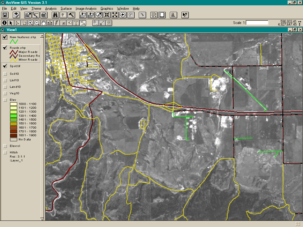
1.1.4. Spatial Data Analysis
The common way of spatial data analysis are calculating the total area in each land use category. Create spatial summaries, such as calculating the average elevation for each watershed. Summary data is useful for gaining a better understanding of conditions in a study area.
In the below figure, summary statistics have been calculated for each land use class showing the number of parcels in that class, the size of the smallest and largest parcel, the average parcel size, and the total area in the class.
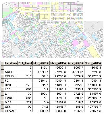
(Spatial Data Analysis)
1.1.5. Spatial Data Output
Shapefiles are a simple, non-topological format for storing the geometric location and attribute information of geographic features. A shape file is one of the spatial data formats that you can work with and edit in ArcGIS.
The shape file format defines the geometry and attributes of geographically referenced features in three or more files with specific file extensions that should be stored in the same project workspace. They are:
- .shp—The main file that stores the feature geometry.
- .shx—The index file that stores the index of the feature geometry.
- .dbf—The dBASE table that stores the attribute information of features.
There is a one-to-one relationship between geometry and attributes, which is based on record number. Attribute records in the dBASE file must be in the same order as records in the main file.
When viewing shapefiles in ArcCatalog (or any ArcGIS application), you will only see one file representing the shape file; however, you can use Windows Explorer to view all the files associated with a shape file. When copying shapefiles, it is recommended that you do so in ArcCatalog or by using a geo-processing tool. However, if you do copy a shape file outside ArcGIS, be sure to copy all the files that make up the shape file.

(Spatial Data Output)
1.2. GIS Integration
This GIS integrations are carried out post deployment of the spatial data in ArcGIS Server (WebGIS). These functions are different from preparation of GIS spatial data (.shp file). This is purely a web development activity, where are building spatial data is a digitization activity. Steps to be followed for the deployment of spatial data in GIS server and integration in web based MIS application are as follows:
Following image depicts the step by step process followed currently for data updation in web GIS platform.
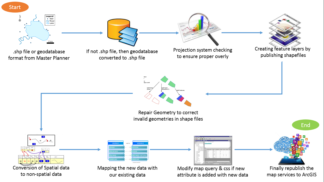
(Workflow of GIS Deployment and Integration)
- Data received in .shp file or geodatabase format from client/ GIS developers
- If the data received are in geodatabase then it need to be converted to .shp format file through ArcMap.
- Projection system need to checked to ensure proper overly of shape file in proper coordinate
- If the projection file received in not form of EPSG:3426 format, then the projection system need to be manually changes to EPSG:3426 format using ArcGIS.
- To convert spatial data to non-spatial data, PostGIS is used to import the data of .shp file to PostgreSQL table structure.
- When .shp file is imported to PostgreSQL, a spatial index Gid is added into the table of PostgreSQL and same Gid is created with reference to the index of spatial data.
- Currently there is no unique id of spatial parcels, so each time of deployment new data has to be mapped with existing data of RDBMS table manually.
- For avoiding this problem a modified .shp file is created with a gid, which is unique for each feature.
- So it is assumed that gid is unique id, whenever modified master plan .shp file received from master planner.
- Mapping the new data with our existing data.
- Modify the views if needed
- Open ArcMap, modify the map query and styles (css) if new attribute filed is added with new data.
- Finally republish the map services to ArcGIS.
- Once the application is deployed in the web API the same API can be called in the web based MIS application for decision making. Below is the snap of the final web based output of GIS application.

(GIS integrated MIS application)